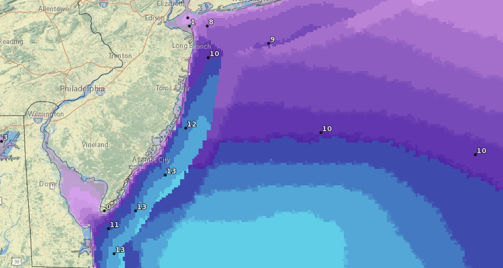
Forecast wave heights (in feet) offshore Saturday, Sept. 23 during a forecast coastal storm. (Source: NWS)
Meteorologists are forecasting a tropical disturbance currently off the Florida coast to intensify and make it way up the coast by the weekend, potentially resulting in a nor’easter or subtropical storm for the Jersey Shore. The impending storm is already prompting some cancellations of weekend events.
According to the National Hurricane Center, the disturbance is a non-tropical low pressure system that is largely disorganized off the Florida coast.
“This system could acquire some subtropical characteristics on Friday while it moves generally northward,” the NHC said. “Regardless of development, this low is likely to bring gusty winds to gale force, heavy rain, and high surf to portions of the Southeast and Mid-Atlantic United States late this week and into this weekend.”
A major local event that will be postponed is the annual Shamrocks by the Sea Irish Festival in Seaside Park, which helps raise funds for the annual Ocean County St. Patrick’s Day Parade.
“With the impending Nor’Easter arriving Friday evening, this is meant for everyone’s safety and security of your equipment and goods in mind,” organizers posted on social media. “We will be rescheduling our festival for Saturday Oct. 7.”
A coastal storm is increasingly likely to affect the region Friday night-Sunday. Besides the flood potential mentioned in the graphic, wind may gust up to 40 mph inland & 50 mph near the coast, which may cause coastal flooding, beach erosion & rips. Not a very nice weekend. pic.twitter.com/qExT1tSUKc
— NWS Mount Holly (@NWS_MountHolly) September 20, 2023
The National Weather Service has issued a rip current advisory for the next two days, and predicts the storm will begin to show its characteristics locally on Friday despite sunny skies. Winds will increase to about 30 m.p.h. from the east, with rain moving in overnight.
During the overnight hours between Friday and Saturday, about a half-inch of rain is expected to fall. On Saturday itself, an additional 1-2 inches of rain is expected, which will be heavy at times. It will also be windy, with a northeast wind around 30 m.p.h., with gusts as high as 50 m.p.h.
Another half-inch to inch of rain will fall overnight between Saturday and Sunday before the storm moves out after 2 p.m. Sunday afternoon, though showers could linger into Sunday night.
The system will move out of the area by Monday morning, forecasters are predicting.
The coastal storm will also mark the return of dangerous surf conditions after two weeks of seemingly nonstop rescues and a string of drownings both at the Jersey Shore and up and down the east coast.
The rip current risk is considered “high” by the NWS for Ocean County both Thursday and Friday. The NWS issues Surf Zone forecasts in two-day intervals.
On Thursday, waves in the surf zone will run 3-5 feet with a water temperature of around 70 degrees. On Saturday, wave heights in the surf will increase to 4-6 feet.
High tide in the ocean occurs at 12:02 p.m. Thursday; Friday’s high tides occur at 12:33 a.m. and 1:04 p.m.
The NWS defines a “high” risk of rip currents as “life-threatening rip currents being likely in the surf zone.”


Seaside Heights & Seaside Park
Seaside Heights School Board Seeking More Participation, Will Change Meeting Times

Police, Fire & Courts
Seaside Park Man, 68, Charged in Fatal Crash With Pedestrian

Ortley Beach & North Beaches
Lottery Ticket Worth $10K Sold at Ortley Beach Acme


Ortley Beach & North Beaches
Abandoned Private Island ‘Mansion’ in Barnegat Bay Poised for Demolition

