Forecasters are not predicting a white Christmas for the Shore area, however a major storm system on its way to the region will produce heavy rain before ushering in bone-chilling temperatures that will fall into the single digits.
Winter arrived Wednesday, with the sun having set at 4:34 p.m. – the shortest day of the year – after a chilly day with temperatures in the 30s. The winter solstice did, however, produce a very warm sunset, which Shorebeat captured in the video embedded above.
The same arctic front which will race through our area on Friday is currently making its way across the central US, where the temperature dropped 40° in just 30 mins this afternoon. This is a very powerful system that will impact the eastern 2/3rds of the contiguous US. https://t.co/e2zBFO9tVf
— NWS Mount Holly (@NWS_MountHolly) December 21, 2022
The storm system is expected to bring warm temperatures and rain to the region by 1 p.m. Thursday. According to the National Weather Service, Thursday will see about three-quarters of an inch of rain fall before the nighttime hours arrive, with a high of 52 degrees. It will also be breezy, with an east wind 10 to 20 m.p.h.
Heavier rain will move in during the evening and overnight, with the temperature remaining steady in the low 50s. A southeast wind will move 20 to 25 m.p.h., with gusts as high as 40 m.p.h. During this period of time, an additional 1-2 inches of rain are expected to fall.
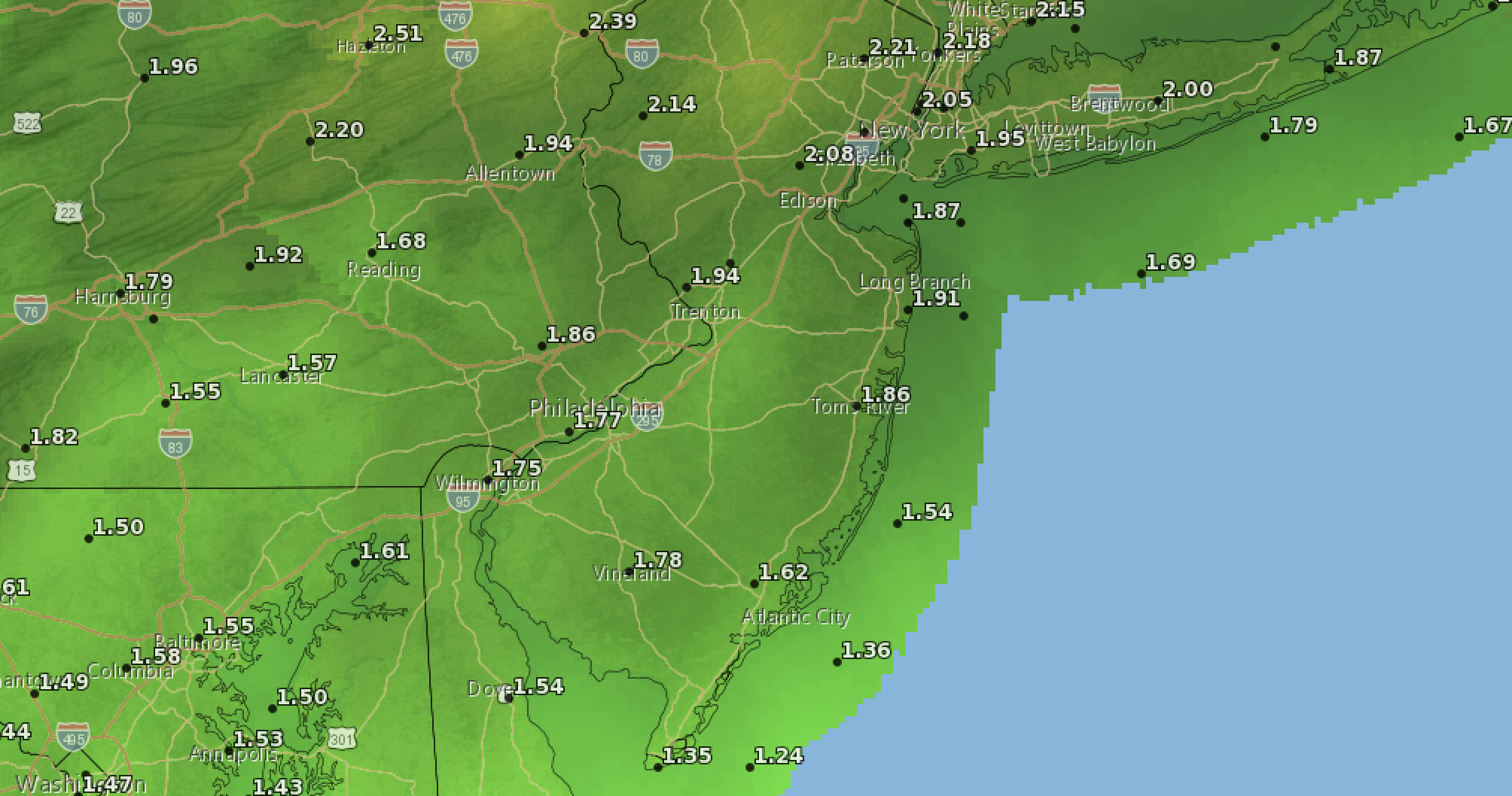
Forecast precipitation totals in the Dec. 22-23, 2022 rain storm. (Credit: NWS)
On Friday, the NWS forecast calls for rain before 1pm, then a chance of snow as the storm exits and temperatures take a dramatic plunge from a high of 53 degrees to a low of 15 degrees – a staggeringly-large temperature differential that could lead standing water to freeze. A south wind will continue to blow 25 to 30 m.p.h. with gusts as high as 45 m.p.h. Little or no snow accumulation is expected for the short period of time it may fall at the tail end of the storm.
The NWS forecast for the Christmas holiday weekend calls for frigid temperatures. Saturday, Christmas Eve, will be sunny with a high of 23 degrees, along with breezy conditions continuing. Christmas Day’s high will be just 27 degrees under sunny skies, with strong winds remaining in place. Monday, likewise, will be sunny, however temperatures are not expected to break the freezing mark with a high of 31 degrees.
Christmas Day is setting up to be a cold one with a forecast high of 25° and a forecast low of 14° in Philadelphia. How would this match with the coldest Christmas Days on record? Here is a list of the 10 coldest Christmas Days. 2022 looks to crack the top 10. pic.twitter.com/ngLbnqoRzd
— NWS Mount Holly (@NWS_MountHolly) December 21, 2022
A coastal flood advisory is in effect for the morning high tide cycle Friday. Up to one foot of inundation above ground level is expected in low-lying areas near shorelines and tidal waterways.


Seaside Heights & Seaside Park
Seaside Heights School Board Seeking More Participation, Will Change Meeting Times

Police, Fire & Courts
Seaside Park Man, 68, Charged in Fatal Crash With Pedestrian

Ortley Beach & North Beaches
Lottery Ticket Worth $10K Sold at Ortley Beach Acme


Ortley Beach & North Beaches
Abandoned Private Island ‘Mansion’ in Barnegat Bay Poised for Demolition

