Radar data of a storm that may develop into a tropical system, July 8, 2020. (Credit: NWS)
Forecasters were warning that the Jersey Shore could experience heavy rain and gusty as a storm system moves in from the south late this week.
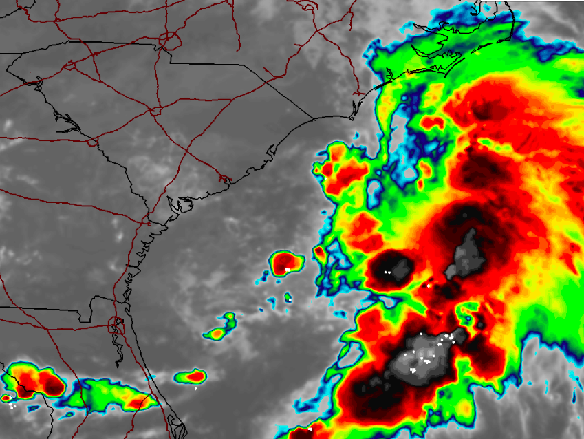
The storm has a 70 percent chance of being declared a tropical storm within the next 48 hours, a statement from the National Hurricane Center said. The NHC also said interests from the Carolinas to New England should be keeping watch over the system, which is currently spinning near the coast of northeastern South Carolina.
“The low is expected to move northeastward near or just offshore of the North Carolina Outer Banks on Thursday, and then turn north-northeastward and move along the mid-Atlantic coast Friday,” the National Hurricane Center said. “Environmental conditions are expected to be conducive for development, and a tropical or subtropical cyclone is likely to form within the next day or so.”
If named, the storm would be known as Tropical Storm Fay (or Subtropical Storm Fay).
Regardless of development, the system is expected to produce locally heavy rainfall that could cause some flash flooding across portions of eastern North Carolina, the coastal mid-Atlantic, and southern New England during the next few days, the NHC said. Gusty winds are also possible along the North Carolina Outer Banks through Thursday and along the mid-Atlantic and southern New England coasts Friday and Saturday.
Based on surface observations, the low associated with #98L is getting very close to moving offshore in the Carolinas. East-weighted convection could tug the low that way too. Assuming it does stay offshore, this has a solid chance of becoming #Fay as it moves up toward the NE. pic.twitter.com/oCTK8KpqQ7
— Andy Hazelton (@AndyHazelton) July 8, 2020
According to the forecast from the local National Weather Service office in Mount Holly, the storm could affect the Shore area any time between late Thursday and Tuesday of next week, depending on the speed and track of the storm after it develops (or fails to develop) off the coast.
“This low pressure system is currently forecast to track close to the region and could bring heavy rain,” a statement said. “Localized minor tidal flooding is possible.”
The Seven Day Forecast is now updated!https://t.co/e7FZPyNTT5#nywx #njwx #pawx #ctwx pic.twitter.com/jGb7XFglFO
— NY NJ PA Weather (@nynjpaweather) July 8, 2020
Rain, sometimes heavy and accompanied with thunderstorms, will move into the region after 8 p.m. Thursday. The threat will continue into Friday. Tropical storm wind speeds range between 39 and 73 m.p.h., however the upcoming storm is expected to be on the lower side of the spectrum, consistent with the effects of an average nor’easter.
Rip currents will also be possible Thursday, worsening on Friday.


Seaside Heights & Seaside Park
Seaside Heights School Board Seeking More Participation, Will Change Meeting Times

Police, Fire & Courts
Seaside Park Man, 68, Charged in Fatal Crash With Pedestrian

Ortley Beach & North Beaches
Lottery Ticket Worth $10K Sold at Ortley Beach Acme


Ortley Beach & North Beaches
Abandoned Private Island ‘Mansion’ in Barnegat Bay Poised for Demolition

