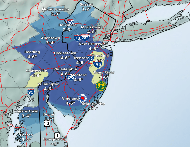
The forecast for the Jan. 31 – Feb. 2, 2021 winter storm. (Credit: NWS)
The National Weather Service issued a winter storm watch in anticipation of a system that is expected to move in Sunday night and last into Tuesday.
The watch runs from 4 p.m. Sunday through 1 a.m. Tuesday.
“Heavy snow possible,” the statement from the NWS said. “Total snow accumulations over 7 inches possible. Winds could gust as high as 50 m.p.h., creating significant blowing and drifting of snow.”
Travel could be “very difficult,” the statement said, and the hazardous conditions could impact the Monday evening commute. According to the NWS, snow will develop west-to-east late Sunday and last through late Monday or early Tuesday. A period of wintry mix or rain could occur Sunday night and Monday morning, especially along and near the coast, before turning back to snow Monday afternoon. The highest snowfall rates are most likely to occur late Monday.
The snow is expected to begin lightly after 2 p.m. Sunday. The overnight low will be 30 degrees, with a high temperature Monday of 36 degrees. The winds should be at their worst Sunday night and Monday.

Police, Fire & Courts
Cops: Juvenile Arrested After 118mph Joy Ride in Seaside Heights, Toms River Kills 2


Seaside Heights & Seaside Park
Seaside Heights OKs ‘Pedacycle’ Tours for 2025 in Revived Experiment


Police, Fire & Courts
Cops: Juvenile Arrested After 118mph Joy Ride in Seaside Heights, Toms River Kills 2

Police, Fire & Courts
Ocean County Sheriff Establishes Drone Command Center in Seaside Heights Amid New Video


