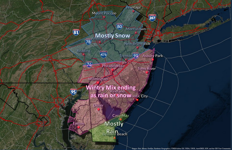
A graphic representing predictions for a winter storm, Jan. 25-26, 2021. (Credit: NWS)
The first winter storm of 2021 is forecast to affect the Shore area Monday and Tuesday (Jan. 25-26), and forecasters are preparing for a mixed rain-snow event.
According to the National Weather Service office in Mount Holly, the storm will begin with a chance of rain after 1 p.m. Monday, mixing with snow after 4 p.m. There will be a high near 38 degrees.
On Monday night, snow is likely before 1 a.m., then the snow will begin to mix with sleet between 1 a.m. and 4 a.m., before changing back to all snow after 4 a.m. The overnight low will fall below freezing, to just about 30 degrees.
A chance of snow before 10am will remain Tuesday morning, followed by a chance of a rain-and-snow mix. It will otherwise be mostly cloudy with a high near 38 degrees.
There is “increasing confidence that the low will track just south of our region,” the NWS office said via social media. “But, it will be close enough to our area that many could see a wintry mix. [Precipitation] type remains one of the more uncertain aspects with this”
Very focused on the Monday-Tuesday event. Working on ironing out details. I am also interested in the Thursday-Friday threat. Don’t sleep on guidance, I smell some mischief.
— NY NJ PA Weather (@nynjpaweather) January 22, 2021
The lack of understanding as to when and where snow will change to sleet and rain has kept forecasters from predicting accumulation totals, or even venturing to say whether there will be any substantive accumulation in the Shore region at all.
Some forecasters are also tracking the potential for a second precipitation event toward the end of next week.


Police, Fire & Courts
Seaside Heights Man, 36, Charged With Failing to Register Under Megan’s Law

Police, Fire & Courts
Cops: Juvenile Arrested After 118mph Joy Ride in Seaside Heights, Toms River Kills 2


Police, Fire & Courts
Cops: Juvenile Arrested After 118mph Joy Ride in Seaside Heights, Toms River Kills 2

Police, Fire & Courts
Ocean County Sheriff Establishes Drone Command Center in Seaside Heights Amid New Video


