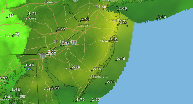
The total rainfall forecast through the end of Monday, Oct. 12, 2020. (Credit: National Weather Service)
The Jersey Shore may experience some of the most voluminous rainfall totals during Monday’s storms, produced by the remnants of what was once Hurricane Delta.
According to the National Weather Service, a long period of widespread showers will continue to impact the region through Tuesday, producing 2 to 3 inches of rain. While flash flooding is not anticipated, nuisance flooding in low lying areas and or areas with poor drainage will be possible.
Widespread minor tidal flooding is possible with the high tide on Monday afternoon and evening for the New Jersey coast. On Barnegat Bay, locally, high tides will occur at 8:48 a.m. and 8:59 p.m.
Coastal areas will be dealing with an east wind blowing from 25 to 30 m.p.h., with gusts as high as 40 m.p.h.
The rain will continue until about 11 p.m. Monday, after which showers may linger through the early-morning hours. Those showers and cloudy skies may last until about 8 a.m. before skies clear, producing an othersise partly cloudy day Tuesday with a high of 69-degrees.


Ortley Beach & North Beaches
Landmark Ortley Beach Breakfast Spot Looks to Expand

Ortley Beach & North Beaches
‘Temporary’ 70-Foot Cell Tower on Route 35 in Ocean Beach OK’d to Return

Seaside Heights & Seaside Park
Beloved South Seaside Park Restaurant Will Remain Open As Developer Seeks to Demolish Block


Seaside Heights & Seaside Park
In Seaside Heights, A $50M Flagship Building Rises Over the Boulevard in a Famed Location

Police, Fire & Courts
Ocean County Sheriff Establishes Drone Command Center in Seaside Heights Amid New Video


