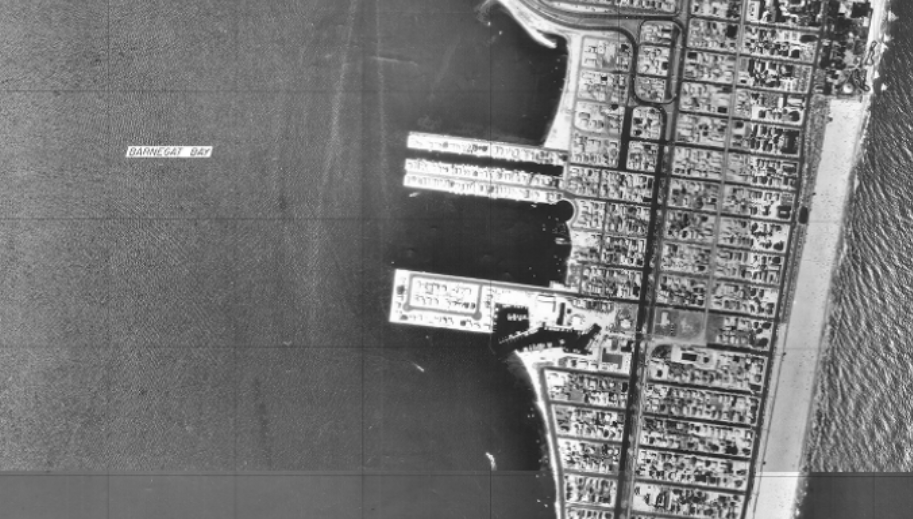
Seaside Park in the NJDEP’s 1977 tidelands base map. (Credit: NJDEP)
Son of Sam was on the run, a blackout left more than 9 million people without electricity and Shaun Cassidy’s “Da Doo Ron Ron” was the number one hit. Such was the summer of 1977, long before Superstorm Sandy, climate change and perpetual flooding issues were on the collective minds of Seaside Park residents.
That summer may soon take on a new significance, as New Jersey Department of Environmental Protection officials have determined that shoreline restoration projects along the state’s bayfront may restore bay beaches back to the levels shown on the 1977 basemap. Seaside Park may soon find itself in the unique position of looking to the late 1970s as a basis for the scope of plans to build out its bayshore, install a second bulkhead and lay down articulated “armor” under the sand in order to deteriorate wave action.
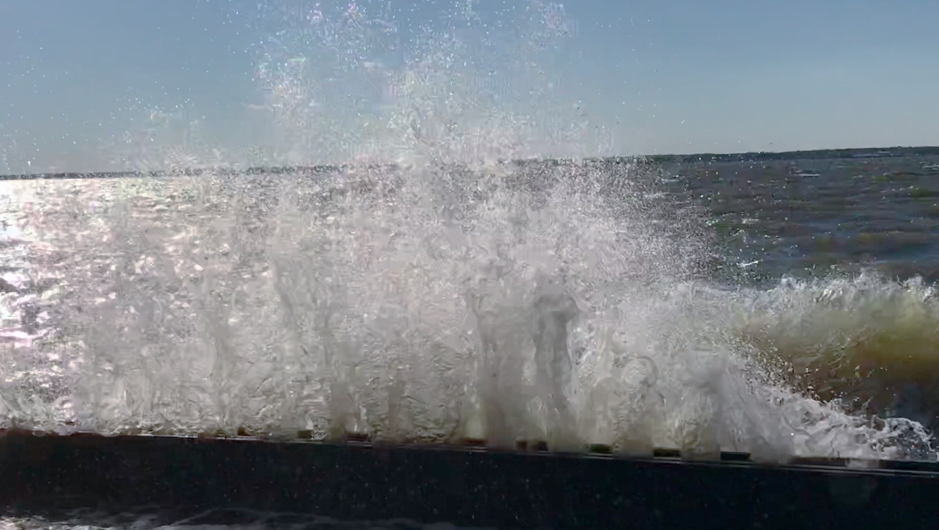
A wave crashes over a bulkhead in Seaside Park, N.J., Oct. 30, 2017. (Photo: Daniel Nee)
The borough council is considering a plan that would include the following: Replenish sand on the bay beaches to the same width as the 1977 basemaps showed; build a second bulkhead (with stairs for public access) to act as a mini seawall in the shoulder of what is now Bayview Avenue; and place matting in strategic areas to keep the sand in place. A living shoreline made of oyster shells designed to help attenuate the force of waves during storms is also an option. The borough, however, is up against an uncertain clock.
“The state is under pressure to spend all the Sandy money so it can be closed out,” said Alan Dittenhofer, an engineer with Remington and Vernick, the borough’s contracted engineering firm.
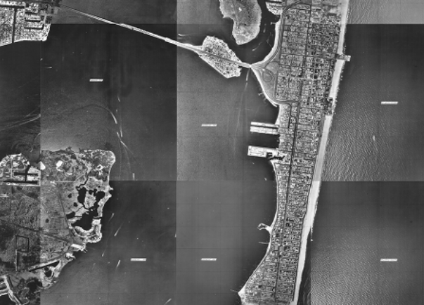
Seaside Park in the NJDEP’s 1977 tidelands base map. (Credit: NJDEP)
The goal of the project will be to protect real estate as well as roadways in the event of a future storm. But residents said at a recent borough council meeting that they also wanted a focus on flooding to be added to any such project. For many, the worry of storm waves lashing up against their homes in a hurricane is once-in-a-lifetime worry, while flooding events have become a routine nuisance.
“The way we have the project designed, we can have a bulkhead constructed and have the beach placed in front of it,” said Dittenhofer. “It looks like beach sand, and you can’t tell it has the articulated armoring under it.”
The sand would come from a quarry and be trucked in, Dittenhofer said, noting that engineers would study the grain size and quality of the existing bay beach sand and find something that matches. Indeed, the sand would be expanded to the 1977 base map level, and a rock toe could be added for extra protection.
“I’m an old man, I remember how it used to be,” said Councilman Ray Amabile. “When I was a young boy you just walked right down to the bay and there was a beach.”
Indeed, today, that beach in some areas has all but disappeared.
Officials are also considering options to tackle the more frequent flooding issues, which originate from high tides that back up through storm drains rather than waves that occasionally crash into the bulkhead along Bayview Avenue. For this part of the project, experts will reconstruct catch basins and “raise some roads,” said Pam Hilla, a project engineer with the Remington firm. The borough will also expand its network of Tideflex valves that attempt to stop water from back up into storm drains through outfall pipes in the bay.
“It’s not going to fix every condition but there will be some relief and some improvement under some conditions,” Hilla said.
“If we really want to mitigate the flooding, we’re going to have to raise some roads,” Dittenhofer added. “The problem is, everyone has to buy in. You cannot have one neighbor saying, ‘I’m not in favor of that’ because you can’t have different yards with different elevations. We had a case in Berkeley where one person said, ‘no I don’t want it,’ and that was it.”
Current plans call for a new bulkhead to be built farther inland, effectively in the shoulder of what is now Bayview, and be two feet higher than the existing bulkhead, which would be covered in sand as part of the replenishment project. The new bulkhead would feature walkovers to allow public access to the bayfront sand. The area between the new and old bulkheads would be covered in vegetation such as dune grass and native plants.
Some residents at the meeting held Thursday night were concerned about a new, higher wall being installed, but the engineers said it was crucial for both the success of the project and the tax dollars that will go into it.
“If we don’t put the wall in, we’re in danger of jeopardizing funding for the project,” said Dittenhofer.
In order to get the project off the ground, the borough council will have to decide on a final action plan, submit it for funding and permit purposes through FEMA and state agencies, then solicit bids for the construction portion. Phases of the project have already been approved by FEMA, but it is getting down to the wire, the group of engineers said.
“The award letter had indicated that FEMA wanted the money spent by August 2020,” said Hella. “But they also know that is not feasible. The only concern is if there are major modifications, the length of the extension would have to be considered.”


Police, Fire & Courts
Seaside Heights Man, 36, Charged With Failing to Register Under Megan’s Law

Police, Fire & Courts
Cops: Juvenile Arrested After 118mph Joy Ride in Seaside Heights, Toms River Kills 2


Police, Fire & Courts
Cops: Juvenile Arrested After 118mph Joy Ride in Seaside Heights, Toms River Kills 2

Police, Fire & Courts
Ocean County Sheriff Establishes Drone Command Center in Seaside Heights Amid New Video


