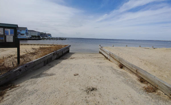
The Lavallette municipal boat ramp. (Borough Photo)
Lavallette residents will have an easier time launching boats and navigating them in borough waters, with a dredging project coinciding with a project to improve the boat ramp about to get underway.
The dredging portion of the project will begin as soon as next week, with the timing crucial since dredging has to be completed by January due to winter flounder migration. The state-funded project will dredge the Lavallette Channel while filling in two large dredge holes that exist just off the bay beach. The holes were created after the 1962 nor’easter and the sand was trucked to the beach for a replenishment project, but over the years, the depth of the water has led to a loss of life, which will be restored by filling the holes in.
Lavallette officials offered some excess sand to the state in exchange for the state agreeing to deepen the channel that runs under the West Point Island bridge, which has shoaled in recent years. The state went back-and-forth on the idea, but has apparently now decided to participate in the exchange, said Mayor Walter LaCicero.
“They’ve offered to do the dredging at no cost,” said LaCicero.
The borough worked with Dr. Stewart Farrell of Stockton University to design the project and enlist the state’s help.
“They actually have started to pre-stage some equipment, and Dr. Farrell and I were working into the late afternoon to finish everything up,” Borough Administrator Robert Brice said Monday night.
The rejuvenation of the borough’s boat ramp, while technically a separate project, will coincide with the dredging of the channel. Set to begin in February, the bulkheading around the ramp will be replaced and the ramp area will be improved. The borough plans on installing a variant of a “living shoreline” style protective revetment to prevent the shoaling over of the ramp site.
LaCicero said devices that resemble geotubes will be filled with oyster and clam shells that will form a man-made barrier using natural marine life. It also likely that the flow of the water in the area of the ramp will be modified by the dredging project.


Police, Fire & Courts
Cops: Juvenile Arrested After 118mph Joy Ride in Seaside Heights, Toms River Kills 2


Seaside Heights & Seaside Park
Seaside Heights Mourns Passing of Boardwalk Legend, Still Working Into His 90s


