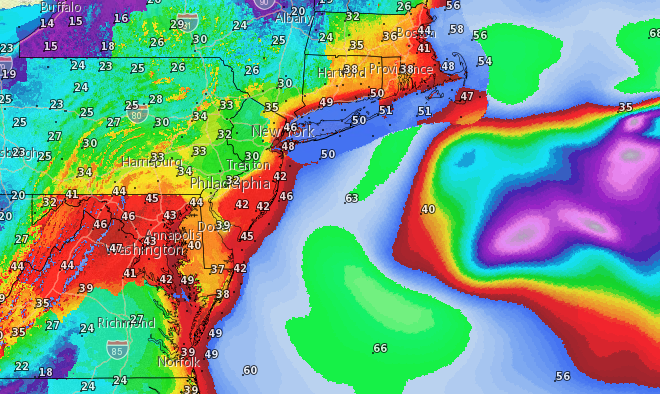
Wind gusts Friday evening, according to the National Weather Service, March 2, 2018. (Credit: NWS)
The National Weather Service has issued a high wind watch, flood watch and coastal flood watch for a significant storm forecast to move in Thursday night and last through Friday.
Rain will begin to overspread the area Thursday after 4 p.m. and get progressively heavier as the night continues, with an inch and a half of rain possible by morning. An additional inch of rain is possible during the day Friday into Friday night, according to a National Weather Service forecast.
Wind will be a major issue in the storm, with the U.S. Coast Guard issuing a notice to mariners warning of 65 m.p.h. wind gusts. On land, wind gusts will reach about 50 m.p.h. with sustained wind speeds between 28 and 34 m.p.h. A high wind watch is in effect until Saturday morning at 7 a.m.
“The strongest winds are expected Friday evening, and winds will gradually diminish through Friday night,” the NWS’s high wind watch stated.
“Our primary concern is ensuring the safety of mariners,” said Lt. Commander Wes Geyer, command center chief of the 5th Coast Guard District in Philadelphia, which covers Ocean County. “We encourage all mariners to keep an eye on the weather and avoid putting themselves or their loved ones at risk as the storm passes off the coast.”
A coastal flood watch is also in effect until midnight Sunday.
“Minor flooding is anticipated with the Friday morning high tide, then moderate to major flooding is possible with the Saturday morning and Saturday evening high tide,” the watch statement said.
Waves will build from 3-6 feet on Friday to 6-10 feet on Saturday. A storm surge between 2 and 2.5 feet will peak Friday evening.
For inland areas, a flood watch is in effect through 6 a.m. Saturday.
“As the rain falls later on Thursday and into Friday, low-lying and poor drainage flooding is likely where the heaviest rain occurs. In addition, as this rainfall runs off into larger streams and rivers, flooding will also be possible Friday night into Saturday,” the watch statement said.

Advertisement

Police, Fire & Courts
Seaside Heights Man, 36, Charged With Failing to Register Under Megan’s Law

Police, Fire & Courts
Cops: Juvenile Arrested After 118mph Joy Ride in Seaside Heights, Toms River Kills 2

Police, Fire & Courts
Cops: Juvenile Arrested After 118mph Joy Ride in Seaside Heights, Toms River Kills 2

Police, Fire & Courts
Ocean County Sheriff Establishes Drone Command Center in Seaside Heights Amid New Video


