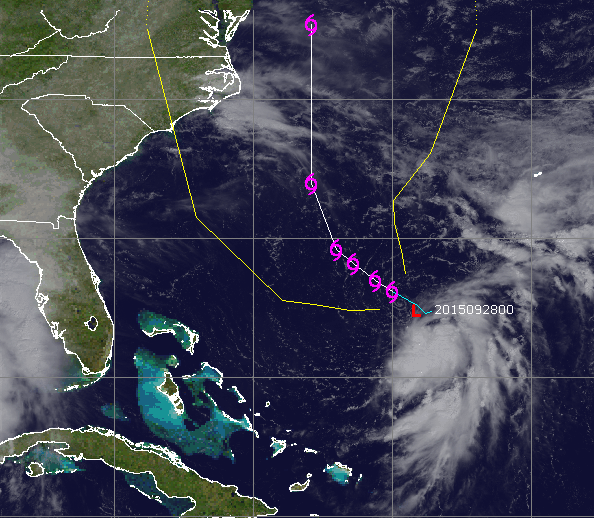
Tropical Depression 11 (Credit: CIMSS)
A newly-formed tropical depression off the southeast coast could move closer to New Jersey by the end of the week, bringing heavy rain, winds and rough surf, forecasters said.
Tropical Depression 11 formed late Sunday and currently several hundred miles southwest of Bermuda. It is packing 25 m.p.h. winds and a great deal of tropical moisture. The storm is expected to become a named tropical storm, but will likely degenerate to a coastal low by the time it reaches the New Jersey area by Friday.
The current forecast calls for the storm to remain offshore.
“Even with the offshore track, some much needed rain could fall,” the National Weather Service’s Mount Holly office said in a statement. “A track closer to the coast would lead to increased odds for other impacts such as coastal flooding and gusty winds.”
In a briefing package released Monday afternoon, the NWS office predicts a “wet and stormy” weather pattern for the week.
“A strong onshore flow later this week will increase the threat of coastal flooding, heavy surf, and significant beach erosion,” the briefing said. “Rainfall amounts of two to four inches are possible this week for the region, with some locations seeing locally higher amounts.”
Later this week, the briefing said, winds will become northeast and intensify. Wind gusts of 20 to 30 m.p.h. are possible over inland locations. Wind gusts of 40+ m.p.h. are possible in coastal areas.
There are two potential time frames for heavy rainfall. The first one is late Tuesday into Wednesday, unrelated to the tropical depression. Another round of heavy rainfall is possible late this week.


Seaside Heights & Seaside Park
In Seaside Heights, A $50M Flagship Building Rises Over the Boulevard in a Famed Location


Police, Fire & Courts
Ocean County Sheriff Establishes Drone Command Center in Seaside Heights Amid New Video


